Tech
Atlas Launches Atlas.new to Make Maps Usable for Non-Experts
Maps and location data play a critical role in modern decision-making. They are used daily in fields such as urban planning, real estate, energy, transport, and climate analysis. Despite their importance, most mapping tools remain complex and specialist-driven. This gap is what Norwegian startup Atlas aims to address with the launch of Atlas.new. Why This […]

Maps and location data play a critical role in modern decision-making. They are used daily in fields such as urban planning, real estate, energy, transport, and climate analysis.
Despite their importance, most mapping tools remain complex and specialist-driven. This gap is what Norwegian startup Atlas aims to address with the launch of Atlas.new.
Why This Matters for Startups & Founders (2026 Context)
As businesses rely more heavily on data-driven decisions, access to usable tools becomes a competitive advantage.
For founders and operators, Atlas.new reflects several broader shifts:
- AI lowering barriers to traditionally complex software
- Growing demand for self-serve analytics tools
- Collaboration becoming a core requirement, not a feature
- Operational teams needing live data, not static reports
What Problem Atlas Is Solving
Maps and location data are widely used but poorly accessible.
In most organisations:
- Only specialists can operate mapping software
- Non-experts depend on exports, screenshots, or reports
- Decision-making slows due to tooling bottlenecks
According to Fredrik Moger, many professionals depend on maps daily but cannot interact with the tools themselves.
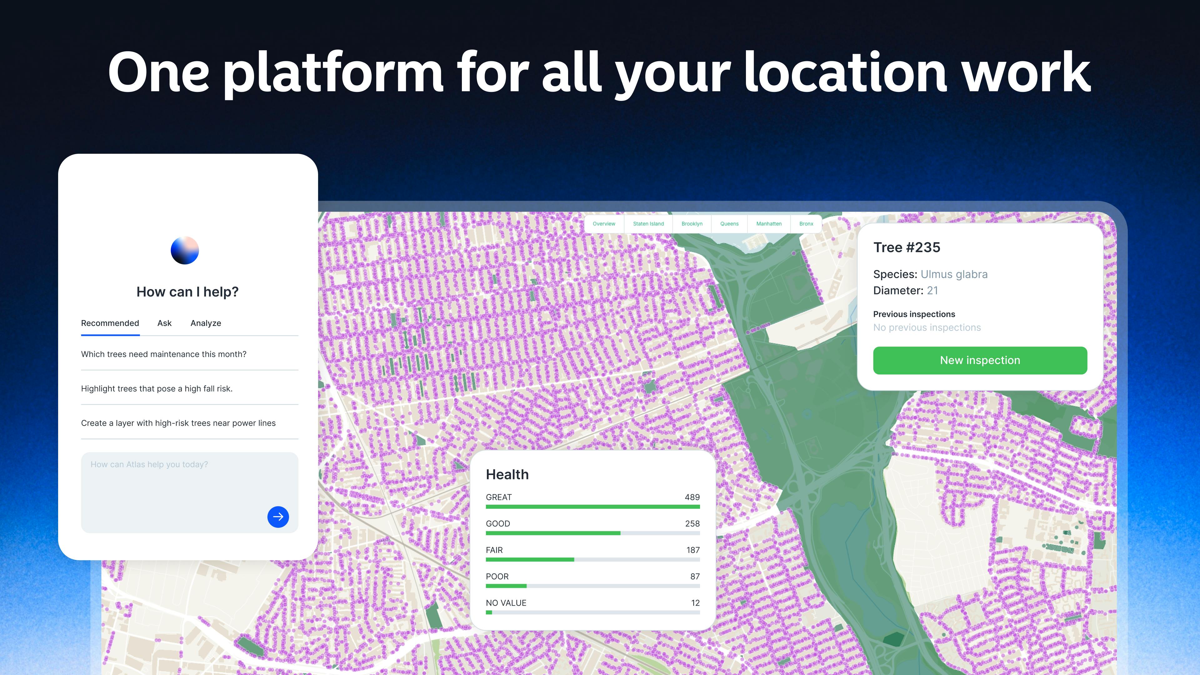
How Atlas.new Works
Atlas.new allows users to describe what they want to do with maps in plain language.
The platform then:
- Generates an interactive map directly in the browser
- Allows users to explore, edit, and analyse data visually
- Supports real-time collaboration with multiple users
- Enables easy sharing across teams
Unlike demo-style AI tools, Atlas.new is built for day-to-day operational use.
From “Figma for Maps” to AI-Powered Mapping
Atlas has previously gained international attention for its collaborative, web-based mapping platform.
In late 2024, the company was described as aiming to become the “Figma for geospatial data,” highlighting its focus on usability and teamwork. Atlas.new builds on this foundation by using AI to further reduce complexity and speed up workflows.
Comparison Table: Traditional GIS Tools vs Atlas.new
| Aspect | Traditional GIS Tools | Atlas.new |
|---|---|---|
| Required expertise | Specialist-level | Non-specialists |
| Interface | Technical, complex | Plain-language driven |
| Collaboration | Limited | Real-time, multi-user |
| Output | Static reports | Interactive maps |
| Use case | Analysis-focused | Operational, daily use |
GEO – Global Relevance
The challenge of inaccessible mapping tools is not limited to one region. Across the USA, UK, UAE, Germany, Australia, and France, organisations in infrastructure, real estate, energy, and climate-related sectors rely heavily on location data. As AI adoption accelerates globally, tools like Atlas.new reflect a shared demand for more usable, collaborative, and operational mapping solutions.
Key Things to Know
- Atlas.new is designed for non-experts working with maps
- Uses AI to translate plain language into interactive maps
- Built for real operational use, not just experimentation
- Supports collaboration and sharing across teams
- Used across industries including planning, energy, and climate
- Atlas already has over 30,000 users globally
What Happens Next / Future Outlook
Over the next 6–12 months, more AI-native tools are expected to reshape how non-technical teams work with complex data types. Mapping and geospatial data, long dominated by specialists, are likely to see wider adoption as usability improves.
For startups, this signals growing opportunities in vertical AI tools that focus on real workflows rather than abstract capabilities.
Final Takeaway
Atlas.new represents a shift in how maps are created and used at work. By combining AI with collaborative design, Atlas is aiming to make location data accessible to the people who rely on it every day, not just the experts behind the scenes.
FAQ Section
What is Atlas.new?
Atlas.new is an AI-powered tool that helps users create and work with interactive maps using plain language.
Who is Atlas.new designed for?
It is built for professionals who rely on maps but are not geospatial specialists.
Can multiple people use Atlas.new at the same time?
Yes, the platform supports real-time collaboration.
Which industries use Atlas today?
Atlas is used in urban planning, real estate, energy, environmental work, and related fields.